Montreal's recent floods reveal the locations of hidden rivers
Old maps reveal all kinds of secrets and, in recent years as heavy rainfalls multiply, scientists and urban planners have turned to centuries-old cartography to understand areas that could be vulnerable to flooding.

James Murchison and his wife made their way into Montreal from Ottawa on Highway 40, as non-stop rain poured over Southern Quebec on Aug. 9.
They'd given themselves four hours to do so, despite the trip normally taking two. Murchison had planned drinks with friends in the city around 8:30 p.m. The couple were staying at his in-laws to attend a wedding over the weekend.
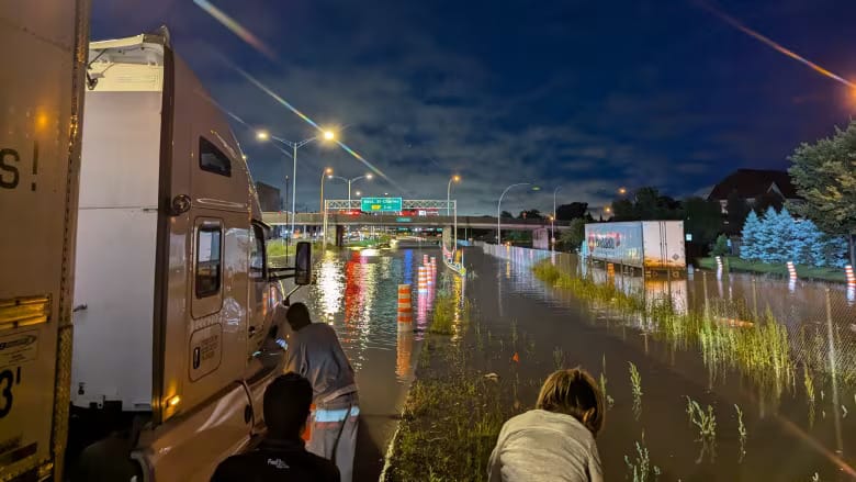
When they hit Kirkland on the western edge of Montreal island, traffic suddenly slowed. Water began to rise around them until it blocked the road in front and behind. Some cars became submerged and before they knew it, Murchison and his wife, and about 150 other vehicles, were trapped.
"It happened really fast," Murchison said. Minutes turned into hours. "We were just kind of stuck on, like, a little island for six hours."

Murchison's plight paled in comparison to the hundreds of Montrealers and Quebecers whose basements and — in some cases in the Laurentians and Mauricie regions — entire homes were damaged by the intense rain. In Montreal, up to 158 millimetres fell in 24 hours; in other parts of the province, that amount rose to 200 millimetres.
Municipalities across Quebec have come under scrutiny by aggrieved residents, but mayors like Montreal's Valérie Plante have defended their work, saying it's impossible to keep pace with the rising frequency of heavier rains brought on by climate change.
"In some cities, it's wildfires or tornadoes. For us, it's water," Plante said in a televised interview on Radio-Canada Tuesday. The mayor said the city has been replacing underground tunnels that were neglected for decades, since she came into office seven years ago. She listed initiatives to absorb rainwater, including sponge parks, creating more green spaces and planting trees. Ultimately, she said, "there will never be zero risk."
But a discovery Murchison made while he was sitting in his car can offer clues about where the water in the city, and on the island as a whole, goes when there's just too much of it.
On the patch of highway, people got out of their cars and started walking around. A group played a game of pickle ball. Some left, wading through the water and returning with pizza. Murchison wondered what about the geography around him could have caused the water to accumulate there. He looked on Google Maps and could see a thin blue line near his location, indicating some sort of stream.

"I'm just curious if I'm — if I'm in a river," said Murchison, who'd heard cities were built over small rivers and stream networks that were restricted to underground tunnels, culverts and in some cases buried.
Searching on his phone, he found two maps of the island of Montreal, dated 1744 and 1892, showing an important river right where he and all those other cars were sitting.
Old maps reveal all kinds of secrets and, in recent years as heavy rainfalls multiply, scientists and urban planners have turned to centuries-old cartography to understand areas that could be vulnerable to flooding.
Because cities are mostly built of concrete, they can't absorb water well and it ends up travelling until it accumulates in low or flat planes. It is in those places that rivers or streams may have once flowed.
All of Canada's major cities were essentially built on top of waterway networks, diverting and confining tributaries to often overburdened sewer networks.
"Our topography recalls the presence of these waterways," said Pascale Rouillé, an urban planner and the founder of Les Ateliers Ublo, a company that helps Quebec municipalities with green infrastructure projects.
"In places where waterways were buried, the ground is often already saturated, so it can't absorb more water and the water can't make its way to a stream," Rouillé said. "It creates an issue."


